Australasian Coasts & Ports Conference, 2023, Sunshine Coast, Queensland
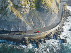
The Te Ara Tupua Ngā Ūranga ki Pito-One Project comprises a 4.5 km shared (pedestrian/cycling) pathway between Ngā Ūranga and Pito-One in Te Whanganui-a-Tara, Wellington with dual outcomes of rail/road corridor resilience improvement and mode shift. The project presented the challenging design requirements of managing the safety of shared path users through a coastal edge design that is controlled by tight geometric (elevation and toe position) constraints, a range of unique edge protection structures, and a bimodal wave climate. This challenge was addressed through site and design specific physical and numerical modelling, data driven overtopping analysis and a forecast model development for safety management during operation. Show more…The range of edge protection structures proposed include XblocPlus armour unit revetments, rock armour revetments with mid-tide berms of varying width, and vertical concrete seawalls with return crest walls. The present empirical guidance on overtopping performance of these structure configurations is not widely developed in literature, at least with sufficient reliability to inform design on this project. An additional complicating factor was a bimodal wave climate, the swell component of which was discovered to have a significant effect on anticipated overtopping flows.
As such, structure- and site-specific physical modelling was undertaken to inform the overtopping analysis at the UNSW Water Research Laboratory. The results of the physical model tests were used to develop site-specific, data-driven formula based on relationships between relative overtopping and relative freeboard, as presented in the EurOtop manual. These relationships were used to understand overtopping potential along the project site both now and in the future through development of a 30-year overtopping timeseries. In parallel, a two-layer phase resolving, non-hydrostatic XBeach solver was calibrated to match the wave transformation of the bi-modal wave climate and physical model overtopping results allowing wave conditions and resultant overtopping flows to be extracted anywhere along the project site.
This was used to inform design crest levels future adaptation timeframes and options, and to develop an overtopping forecast model to inform path warnings and closure during operation. The results of this analysis highlighted the importance of understanding site-specific influences on overtopping flows, not all of which are able to be fully understood through adoption of standard empirical overtopping formula. Show less…

